As you may know, Lisa and I are now living in Vero Beach with no boat at all. Lisa has a new hobby taking pictures of cruising boats on the ICW as they pass our condo. She posts these pics on Trawler Life so keep an eye out and you may see your boat. To make her “job” a bit easier I set up a simple AIS station that talks to an iPad running TZiBoat. Just like on Privateer, she gets an audible AIS proximity alert and then heads to the window to set up the photo shoot.
It is possible there are others like us who live on the ICW and would also enjoy keeping track of boat traffic so I am posting the set-up I am using. Yes, we are on land but the gear would work equally well as an emergency back-up on a boat for an all up cost of about $210.
The heart of the system id the AIS receiver from Quark Electronics.
My setup has the black box plugged into a USP power supply and a handmade VHF antenna connected via a short BNC cable (Amazon $8). The VHF dipole is just two pieces of inner core from a piece of coax about 16.7 ” each which works well at 162 MHz. The two dipoles join at a connector (Amazon $6 for 2).
The antenna itself is taped to the plastic molding between two panes of glass on the inside of the exterior wall facing the ICW and gets at least partial coverage of the waterway. Our windows are impact rated and UV tinted so are not good conductors. With this set-up, our range is between 2-3 miles. It would be better if I could lead the antenna outdoors, but no easy way to do that.
Here is a screen shot from the iPad connected to the AIS via wifi, with the AIS in station mode on our home LAN. The big RED boat (i wish) is us. The GREEN boat is anchored, the RED boat (Island Fever II) is tripping the AIS proximity alarm and the ORANGE boat info is being received from the TIMEZERO cloud data server over the internet. Note that RED and GREEN signals are near real time but the ORANGE boat signal came from our AIS receiver as a node in the crowd that fed the server. Since the ORANGE boat is now out of our range the signal will time degrade and soon disappear.
At installation one has the choice of setting the AIS receiver in either ad hoc mode ( wired or wireless link direct to your device) or in station mode ( as a node on your local LAN). In station mode, when using capable nav software such as TZiBoat the system acts like a virtual AIS ground station feeding the TIMEZERO cloud server. Other systems, such as Predict Wing and AquaMap perform this integration in a similar fashion.
Not quite the same as being aboard, but then when I now hear the AIS proximity alarm I don’t need to run to the bridge to take evasive action!
We sold our beloved Krogen this summer (2024). Painful to see her go. The decision to sell her was wrapped up in a bigger decision to ease out of the live aboard lifestyle, albeit in baby steps. More on that later.
As our faithful readers know, we have been full time cruising on the Krogen for the last eight years, following the seasons North to South. and back. Our time in the Bahamas has been wonderful and even if the trips up and down have been at times tedious, and at other times overly exciting, we have enjoyed every minute.
So why get out, you may ask? As I look out the picture window in our apartment in Newport, RI and see the cold wind kicking up the water in the now empty harbor, I ask myself the same question. Two issues drove the decision, first off, I am not getting any younger and at 76, I can tell I am not as sharp as I used to be. A little slower to respond during complex maneuvers, getting behind the power curve, as they say. In my military flying years ago and then later in my boat driving days, I looked forward to challenging maneuvers. When in the past a tricky parking procedure, wind and current and tight quarters for example, would excite me, of late it just built the anxiety. Better to go out on a high note.
The second reason we decided to ease out of this lifestyle was, frankly, it was expensive. For us the boat represented a major portion of our life savings. Every year it was worth a little less and so every year our net worth dropped along with it. That worked OK for the last eight years but wasn’t sustainable forever. And keeping her in perfect condition, which it seemed I owed her, wasn’t cheap either. An understatement.
But we weren’t ready to give up the life style completely. We have now entered our next cruising phase, which will be as part time cruisers aboard a different boat and part time land lubbers (hence the cold and wintry scene as I write this).
Our current plan is to cruise New England waters in the summer then park the boat and live on land somewhere warm in the winter. That all sounds a little loose because it is. Just now I am waiting on a slot for cataract surgery in Boston in January, which is why we are here in Newport for the winter. We had originally thought we might just make Newport our permanent home, but it was 27 degrees the other morning. Enough said about that experiment.
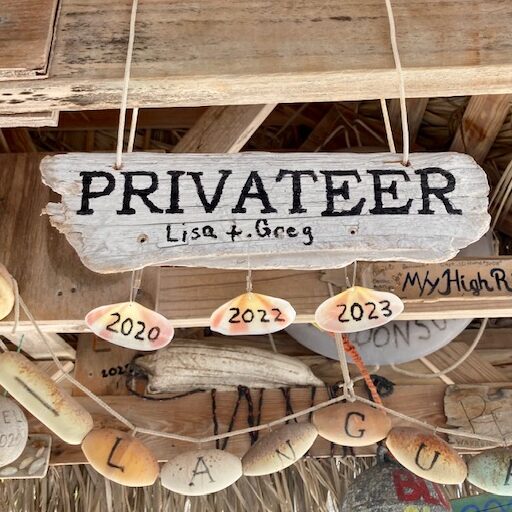
With all that preamble, lets get to the fun part, the new Privateer. She is a Back Cove 372. This boat would best be described as “Down East style” and is sort of a poor man’s Sabre. Back Cove Yachts is the sister company to Sabre and the Back Coves are the simpler and more basic of the two. A goal in choosing the next boat, and the Back Cove in particular, was to simplify my life as captain and chief mechanic. While Sabres are twins with IPS drives, Back Coves are singles with direct shaft drive. A picture:
Privateer at Bristol Marine for haul out. Fall 2024
We bought her in September, 2024, and managed to get a few local cruises in before the cold weather forced us to get her hauled. First impressions are encouraging and its fun to go 15 knots and get there in half the time. That said, the ride is not nearly as relaxing as in the Krogen.
So after going through all that trouble and expense, why sell the new Privateer? That’s a longer story, but the quick answer is, it was time to move to Florida full time. More on that soon.
Cat Island is one of the Bahamas Out Islands, meaning it is other than Grand Bahama or New Providence. But that doesn’t tell you much about Cat. New Providence and Grand Bahama make up 83% of the country’s population, while Cat has only 1,6oo residents scattered over 150 square miles. While there is a significant expat population, as well as some long and short term renters in season, there aren’t many resorts or hotels, so a visitor gets a sense that this is a Bahamian island for Bahamians, but all are welcome. Quite welcome. Because of the lack of tourism, the folks you meet are genuinely happy to meet you. Please greet each person you encounter and you will surely get a warm response. One encounter we had with a gentleman proves this point: we were approaching a commercial wharf looking for a place to tie up the dinghy. A man who had been relaxing in the shade approached us to help us find a spot. When we came back from shopping, we had a tip ready for him. His hand was never out, he was just trying to be helpful. No tip needed.
This was our third visit to Cat Island and, thanks to some decent weather, our longest. Cat has many beautiful anchorages, as long as the wind has some east in it. Any significant west wind will send a cruiser to either Hawks Nest Marina on the southern tip of the island or to another island with better protection. This year we were able to anchor out for ten days before ducking into Hawks Nest Marina for four days to weather a front with a lot of NW wind.
There are no dingy docks anywhere on the island. Most of the beaches are steep to, with a ledge at low water so its easy to beach the dinghy and tie off to a shoreline tree. There are some areas with rocky edges so you will need to be careful.
Even after combining our first two visits with this last trip we still failed to checkout everything on our wish list. Therefore, while this post contains mostly first hand experiences from our visits, we have included a few suggested sights that we tried to visit but weren’t able to. The post will cover navigation and anchorages first(north to south), then cover things to do, places to eat and where to shop. I have included phone numbers where possible. Many of these businesses are also on WhatsApp and/or Facebook Messenger. I suggest contacting any business/restaurant before visiting.
Navigation and Anchoring
Navigating the banks (west side) of the island is straightforward but there are areas of coral that are less than 5′ below the surface at low tide. The Explorer charts do a good job of identifying these areas so, armed with good light you should be fine.
We found nothing but deep sand wherever we anchored. While there are significant grassy areas, there are always plenty of white sand areas. Most of the shoreline is relatively steep to, so you can come in much closer to shore than the Explorer charts suggest.
Cat’s windward shore is the open Atlantic so any significant ocean swell is likely to bend around into the anchorages. This can be quite noticeable when anchored in the northern areas when a NE swell is running outside. It is easy to get fooled by a local SE breeze and anchor to avoid the wind chop and then get rolled by the ocean swell from 90 degrees out. We used our flopper stoppers much of the time. Specific strategies to avoid the ocean swell will be covered in each anchorage.
Shannas Cove
Shannas Cove provides good protection from east winds and decent protection from minor swell from either NE or SE. With mild conditions we anchored in the middle of the bay. The north end, in front of Shanna’s Cove Resort, is a bit shallow. We anchored in 10′ and the area carried 7′ to near the beach. The SE corner can provide decent protection from a SE swell. The beaches to the north are deserted and spectacular. There is even a cave on one beach that is accessible at low tide. There are some excellent coral fields as well but it was too rough the day we did our dinghy explore. Dinner at Shannas Cove Resort (242-359-9668) was excellent. Maria and Gregor are your friendly hosts, originally from Germany and they serve a fixed price($60), fixed menu three-course gourmet dinner. They had a new chef from Switzerland who did an excellent job. Call ahead for reservations.
As you approach the bay you will drive over a series of sand and grass ridges and you will loose a few feet of depth each time. We never saw less than 8′ MLW on our approach from the SE, maybe 7′ MLW on the way out southbound.
While we did not anchor there, the area south of Orange Creek Point would provide good protection from NE wind or swell. Additionally, Gregor from Shannas Cove Resort mentioned that Orange Creek Food Store (242-354-4110) was a good, small store (closed on Saturday). We did not have a chance to visit it.
Pigeon Cay and Pigeon Creek aka Alligator Creek
Pigeon Cay provides another spectacular beach, excellent holding and protection from east through north. We even handled some moderate NNW with just a bit of wrap around chop getting to us.
Pigeon Cay
We first anchored to the east to avoid a SE swell, then moved to the NW spot to escape a bit of NNW. The area around the NW anchor spot is excellent white sand with occasional large coral heads that provide decent snorkeling off the back of the boat. The beach drops off quickly to 6’+ and smooth sand extends to about 100 yards off the beach. Beyond that, there is a mix of rock and sand so you will need to pick and choose a place to drop. We anchored about 200′ off the beach in 10′.
Besides the coral, we came here to take a trip up Pigeon Creek. It is famous for its turtle population but we didn’t see many. While the main creek is wide and deep there are many branch creeks that would be perfect for kayaking. Had we had more time, we would have towed the kayaks with the dingy to access these side creeks that extend deep into the mangroves.
Alligator Creek
Benett’s Harbour
We anchored at Benett’s Harbour specifically to eat at Da Island Kitchen (242-354-6003) and buy some of Chef Andrew’s bread. Unfortunately, he was closed. That’s the second time we visited to find him closed. Suggestion: call ahead. That said, the anchorage was protected and pleasant. Mix of locals and expats live in the modest homes on the beach. The area carries 7′ to near shore. The two small coral heads are visible and are deep enough to ignore. Speaking of coral, near the beach we snorkeled a little patch coral. It was nothing exciting, just an easy little spot to check out the fish. Walking the beach is very nice and we were welcomed to the neighborhood by at least three different folks. We did not make it to Yardie’s (242-354-6076) for drinks or food, but hear it is quite an institution on the island and withing walking distance. We did see it on a previous visit and I recall they serve in a carport, very low key.
Smith’s Bay
This is the commercial dock for the area. We went in by dinghy from where we anchored about a mile south at Fernandez Bay, and tied to a bollard on the concrete wharf. Alvernia Foods Store (242-342-2042) is just across the street and is thought to have the best produce.
Fernandez Bay
Fernandez is an inviting bay with good protection. Choose the NE or SE corner of the main bay or slide in south of the small island. Call ahead to Fernandez Bay Village Resort (242- 824-3043) for lunch or dinner. We failed to do so and they were closed for a post-Christmas break. We had a nice lunch there last year. I was so happy to finally anchor here, as we had heard that snorkeling the coral near the small island was nice. Ultimately we decided not to stay and the snorkeling was not to be, darn!
Update (March 2023) We went back to Fernandez and this time enjoyed a nice happy hour at the resort. We also snorkeled the coral around the islands in the bay. While the coral was decent, there weren’t that many fish. The water was also a bit cloudy, likely due to some remnants of a westerly breeze.
New Bight
New Bight is a popular cruiser hang out with Fish Fry restaurants, bakery, etc. Holding is excellent throughout the bay. You can tuck up into the NE corner to escape a northerly swell and even weather a little NNW wind event. Not good if winds approach south. The east side of the bay is steep too, but the north end is shallow and hard with a rocky bottom. If you are going to the Fish Fry area you can safely run the dingy up onto shore, but not if you are trying to get to restaurants or groceries on the north of town. Better to park at Fish Fry and walk.
First priority when visiting here is to climb to The Hermitage on Mt. Alvernia, the highest hill in the Bahamas (206 ft). You can easily see the white structures from the anchorage. It is a miniature monastery, just big enough for one person. Beloved Father Jerome , who built churches all over the Bahamas, had it built for his retirement.
Don’t miss Olive’s Bakery (242-342-31340) in the kelly green house. Buy her amazing cinnamon swirl bread and try her “flour cakes”. They are a Cat Island specialty that is like a small biscuit flavored with cardamom (I think). The Fish Fry stalls are great. We tried CD’s and another with no sign. Duke’s looked popular for conch salad. Also at CD’s you can inquire about any upcoming Rake N Scrape music events. If you gather an audience from the anchorage, they will likely play a little for you. Bring money for tips. Cat Island is the home of Rake N Scrape! There is a new beachfront restaurant called Tingum Dem. You can see their gazebos from the anchorage. Everyone loves their wings. There is a small white building, just south of the police station and BTC tower called Bluebird Restaurant. It is run by a group of elderly sisters that know home-cooking! They mostly serve weekday lunches and you can call ahead to let them know you are coming on VHFch16. Don’t miss their spicy potato salad.
New Bight Food Store (242-342-3011), also known as Gilbert’s is about a mile or so north of Fish Fry. We walked to the store and asked if they could give us a ride back to the beach with our groceries. They obliged, but this was several years ago. Best to ask before assuming this is possible.
Old Bight
Anchoring at Old Bight puts you in front of Rollezz Resort and Restaurant (242-557-0005). Again, you can get pretty close to shore with the big boat, maybe 100 ft. off, and beach the dinghy. This is where you want to be for strong SE winds and swell. The owners of Rollez, Yvonne and Carl Rolle, are friendly and welcoming to cruisers, but you need to call ahead for dinner reservations. They serve a lovely fixed price ($48), fixed menu, three-course dinner. It is a wonderful experience and very high quality. If you want to stretch your legs, it is a mile walk to a good bakery, Alnor’s (242-342-4131). Follow the driveway out of Rollez Resort to the main road and go south for about a half mile. They are famous for their coconut bread. Be sure to try their little flour cakes, a Cat Island specialty. Call before you go, to make sure they are open.
Joe Sound Creek (Update March 2023) We took the kayaks into Joe Sound creek and a few of the mangrove tributaries. Plenty of turtles, juvenile sharks and the like.
Hawks Nest Marina
Hawks Nest s a totally protected marina at the south end of Cat Island. We have ducked in here twice for weather. The channel is dredged so you need to be in it. Best you cross reference the Google Earth image so you can see the channel. 8′ minimum at low tide in the channel. There are a few marks in place. The reds are red and the greens are faded to white. They sit on the edges of the channel. Note that the chart registration (Explorer, CMAP, etc) is way off, so if you plot a course down the middle of the channel, it will put you on the rocks if you try and drive your route. I transferred coordinates from Google earth to my chart plotter. Anyway, if you follow the channel markers, you will be fine. I thought it was a bit tricky, but the 105′ yacht behind us had no issues.
The current is impressive on the ebb, so plan on slack or near slack rising, if this is your first time. Slack high is about two hours after high tide using the Cat Island tide station and 1:45 hours after low tide, more forgiving towards the end of the rising tide. There is no current inside the basin, but it can be tricky on entry if your bow is out of the current while the stern is still being pushed or pulled by the current.
The marina is run by great folks. Jerry, the dockmaster is happy to help you. The small resort portion of the facility is a quarter mile from the marina. They have a clubhouse/restaurant with serve-yourself honor bar. They typically serve breakfast, lunch, and dinner. Be sure to place your dinner order in the afternoon. Their pool is a lovely place to relax and look out at the beautiful waters. We have rented a car from the office on both of our two visits. Anton, the manager, is happy to assist with this.
Port Howe
This bay is on the south end of the island. We have never used it but we talked with locals who have kept there boat in here for years. And the dive boat from the Greenwood Resort parks here. Often swelly but excellent protection from north wind cold fronts. The barrier reef effectively breaks much of the swell.
Atlantic Beaches
During our time with our rental car, we were interested in exploring Atlantic beaches. We took the rough, but drivable road across from Smith Bay to the area near a closed resort, pictured above. It was a beautiful pink sand beach, great for walking and hunting for treasures.
Greenwood Resort
Another stop on our rental car explore was Greenwood Resort (242-342-3053), in the southeast Cat. We called ahead and asked to join them for lunch. We had a great meal and then explored their lovely pink-sand beach. They have some chairs to relax in after you dine. We also walked around the resort. They also have a nice pool and grounds. They specialize in SCUBA diving and kite-surfing.
Our final stop with the rental car was Da Pink Chicken (242-474-1133). This is the definitive dive bar. Only open Friday, Saturday, and Sunday, 2pm-sunset. We happened to be there on a Sunday, and it seemed that everyone we had met on the island was also there. Sunday is the day to be there! Maybe everything else is closed?
Two more places worth mentioning, if you have a car: Da Smoke Pot (242-354-2094) is run by Julien. We stopped by on a previous visit and chatted with him, but he had not reopened yet after Covid. Also consider Hidden Treasures Restaurant. We had lunch there when they used to be located at Fish Fry in New Bight. But they had a fire and have since moved a mile or two north, on the main road. Both of these places get rave reviews.
A helpful hint to visiting Cat Island is to join the Facebook group, The Cat Island Chronicles. It is full of helpful folks who can answer any questions you have.
We have been anchored in various spots in Mobjack Bay for the last ten days or so. Quiet, peaceful and serene. That is, until the other day. We had a line of thunderstorms ride over us, bringing gusty winds touching 50 knots a couple of times. We were oriented fairly well as the winds were mostly out of the southwest.
North River, Mobjack Bay. North is up.
The winds were strong enough to kick up some waterspouts as the gusts were funneled down Back Creek just west of us. With the winds came some pretty heavy rain, so between the rain and the waterspouts, visibility was poor.
Prior to the arrival of the storms I had been watching their advance on my radar app. While there was a NOAA warning for high winds and hail, I didn’t pay a lot of attention. (NOAA is always saying that..). I was looking at the intensity of the cells and it kinda looked like the strongest cells would pass both north and south of us so I wasn’t too worried as we made our way to the pilot house to watch the show.
As the skies darkened I took one last look at the radar update and saw the gap between the two cells disappear and nothing but red filled the screen in front of our location symbol on my iPad. At that point the wind arrived and I was beginning to think I had underestimated the intensity of this one. Probably should have started the engines as well. Nothing behind us to drag into, however.
When the wind arrived the gusts went from 20 knots to 50+ knots quickly and the direction changed 20-30 degrees with each gust. AT 85,000 lbs, we don’t usually get pushed around or heel much. But a couple of the gusts caught us broadside, pushing us over about 20 degrees and sending us off in a new direction.
The sensation when we reached the end of our chain was more a subtle deceleration than an abrupt snatch and I would ascribe this to the fact that we were anchored in deep mud and I would guess the last ten feet of chain was in the mud. I go into all this description because as trawler cruisers we prepare our boats to handle this sort of weather event but rarely see it. What follows is anecdotal, one person’s experience in one specific event, but possibly some general rules of thumb can be drawn from the lessons learned.
First off then, a bit about our anchorage. We chose the spot to provide some protection from the south. There were some tall trees on land but most of the terrain around here is low and the river beds slope gradually to the shore so one can’t anchor too close to land. In the photo below you can see how far out the docks run in order to find navigable water.
North river anchorage. Privateer looking south towards land.
After the storm abated I went out in the dinghy and checked depths. Turns out we could have moved about 200′ closer to shore. When we arrived here a few days prior, the wind was out of the north so limited what we could do with what was then the lee shore. Once I knew a storm was coming we could have moved a lot closer to land and the protection of the trees.
Our tackle consists of a 55kg Rocna Vulcan anchor with 7/16″ HT chain. We use a 1.25″ nylon snubber that feeds from a deck hawse down to a bow eye at the waterline and then to the chain, connecting with a soft shackle. The effective length of the snubber is about 13′.
At this location we saw 10′ at high tide and had 70′ of chain out, measured from the bow eye, so 7:1. When we pulled anchor the next day I estimated that the anchor was sitting 3′-5′ below the depth read by the transducer. Based on our track before and after the event, I would estimate we dragged about 10′.
All that description reads like a pretty typical set up and anchoring routine. One question some might have is about the size of the snubber line, at 1.25″ way oversize for the job and unlikely to stretch at all. In the past I used lesser diameter line in order to provide stretch and reduce the violence of the snubbing event. I tried to estimate the loads, then subtract the strength degradation due to knots, wear and tear, the change in direction at the bow eye, etc. Then I tried to estimate what the “just right” amount of stretch should be, 10% would be helpful, 20% might weaken the line..? And what wind strength should I use in the equation?
In the end, I gave up on the goldilocks snubber, installed the mother of all snubbers and forgave stretchiness as a feature. In this one specific weather event, with this bottom material and this scope, it turned out I didn’t need any stretch. The boat rounded up at the end of each swing relatively smoothly. I can attribute that observation to either the weight of the chain or the mud it had to pull through, or both.
We anchor a lot in the Bahamas, usually in good sand. A typical set often looks like the photo below.
anchored in the Exumas
We see 30 knots in the Bahamas often. A couple of times I have gone down to observe the action of the anchor and chain in these conditions. What I find is that with 70′ of chain out, in 10′ of water, the last 20′ will stay on the seabed through most of the swings of the boat. At the end of the swing the direction of pull changes about 20 degrees and there will be a modest tug at the chain to anchor shackle. So at 30 knots, the chain maintains at least some catenary even at the end of a swing and the “snub” is gentle. The feeling of motion while on the boat is minor at 30 knots, more noticeable at 35-40 knots and at 50 knots the sensation is strong enough to suggest I need to hold onto something.
A note about all this for any sailors out there reading this. When at anchor in high winds on our sailboat we would actually sail from one swing to the next, accelerating right up until we came to the end of the chain. The arrival was abrupt, along with the change in direction. We also covered a lot more territory than we do with this trawler. On Privateer we decelerate as we approach the end of the chain and then fall off in the other direction. This action is easier on the chain and snubber than it was on the sailboat, so sailors might take all this with a grain of salt and stick to their stretchy snubbers.
Just kidding. These two inquisitive reef sharks followed us into our anchorage in the Exumas.
Reef sharks visit Privateer
This picture was taken with a GoPro with underwater filter attached. I have it mounted on a 4′ stick and for this I had it in the water off the swim platform. I put it on time lapse, one pic per second and just shot away while these guys were swimming about. Got lucky with this shot.
Shark looking for a hand out, or a hand!
These are both Caribbean reef sharks. According to records of shark attacks, a low threat to swimmers. From what I could find on the internet, less than 30 recorded bites by reef sharks, none fatal. Still, when they swim up to you they do get your attention.
We are on a ball at Cambridge Cay mooring field in Exuma Park. Unfortunately, years of visiting boats throwing food scraps overboard have trained the sharks to follow boats coming into the area from Exuma Sound ( as we had done that day) to get fed. We spend a month here each season as park volunteers, harbor hosts for the mooring field, so we see all sorts of bad behavior (by humans, not sharks). We often see mega yacht crews entertaining their guests with shark feeding shows but occasionally see cruisers doing the same. Mostly folks just don’t know any better so part of our “job” is to inform visitors not to feed the sharks. Against park rules. Would seem like a no brainer, but we watch folks feeding sharks off one boat while kids are swimming off another. Thankfully, this doesn’t happen too often. We ask folks to hold their food scraps until they depart the mooring field. A good practice for any anchorage in the Bahamas. We are not, by any stretch, shark experts so we have researched the subject of sharks interacting with humans. Best we know, most of the types of sharks usually seen while swimming in the Bahamas will ignore people in the water, unless the sharks are feeding.
Reef shark with remains of fish hook
In Exuma Park we mostly see Reef sharks, which have a reputation for being shy around divers and will swim away. But there have been occasional bull sharks here, although we haven’t seen any this season. Even a few sightings of a hammerhead. Shark bites in the Bahamas are quite rare. One a few years ago near Rose island but that was a swimmer getting to close to a commercial shark feeding show. A few recorded attacks of divers while spear fishing. So all in all, not a significant risk. That said, I was in the water a while back, cleaning the hull. Water was about 10′ deep and a shark swam directly under my feet. I was out of the water in a flash, only realizing a minute later that it was just a harmless nurse shark. 10′ is 10′ when it comes to sharks!
Lisa and her new BFF nurse sharks
We were at the Hawks Nest marina at Cat Island last month and here, like at some other marinas, the sport fishermen conduct shark feeding shows when they clean fish in the evenings. We were watching one evening and there were 10-15 sharks in the scrum; reef, maybe one bull and many lemon sharks. The lemon sharks were definitely the most aggressive.
Feeding frenzy at fish cleaning station
Easy to see how shark behavior in the presence of food could be dangerous to swimmers nearby. During this feeding event someone through a small stick in the water and the sharks devoured it along with the fish scraps.
A while back I posted about some of our experiences crossing the gulf stream, good and bad. That post discussed various approaches to getting across as quickly and easily as possible. For this trip we were heading to West End from Lake Worth inlet, using all of a fairly narrow weather window.
For planning purposes, I calculated 55 nm at 94 degrees (T). I estimated the current to be an average of 2.5 knots for the 40 nm of the stream. That would equate to an average speed of 6.5-7 knots and 8-9 hours. Since the route is roughly perpendicular to the stream I chose to take the rhumb line route rather than play the current.
I used NOAA gulf stream data, sourced from the Passage Weather App and weather from NOAA, Windy, and Chris Parker. The weather forecasts were generally in agreement that conditions would be decent, but within that broad comment, there was a fair amount of variability, as you will see in a minute. Since we were looking at about 12 hours of relative calm between two cold fronts, that would likely explain the range in the forecasts.
For this post, I will first present the forecasts and planning data, then the actual results. We will cover both weather and GS current forecasts. So lets start with the NOAA GS forecast, courtesy of Passage Weather, for Friday, 15 Jan 2021:
This forecast for GS current shows a mostly yellow (2-2.5 knots). From NOAA data the west boundary of the stream was 7 nm from Lake Worth Inlet. A rough estimate of the eastern boundary put the GS about 13 nm off West End for a total width of 35 nm.
The GRIB models are presented next:
The top two rows of numbers are the gradient and gust winds from the Euro model. The next two rows are the US model, them Meteo and NAM. Note that the Euro shows a spike in early afternoon. (that spike never happened) Otherwise, the winds were predicted to be light out of the west.
Weather Forecasts:
NOAA:
For Friday, as of Wednesday:
West winds around 5 knots becoming south southwest in the afternoon. Seas around 2 feet. Period 5 seconds. Intracoastal waters a light chop. Slight chance of showers in the morning, then chance of showers in the afternoon.
For Friday as of Thursday:
Northwest winds 5 to 10 knots becoming west southwest in the afternoon. Seas around 2 feet. Period 5 seconds. Intracoastal waters a light chop. Slight chance of showers.
For Friday as of Friday Morning: No change from Thursday
Chris Parker: Northern Crossing Route
For Friday as of Wednesday:
NW-N up to 15k/2-5′ Fri15
For Friday as of Thursday:
L&V<WNW-NW up to 15k/1-4′ tonight-Fri15;
The actual weather and sea conditions were pretty close to both NOAA and Chris Parker as of the day before. As you will see in the table coming up, we started off with NW winds in the 15 knot range, with some gusts to 20. The winds died off during the morning and did back to the SW just as we arrived in early afternoon. Note that these human-generated forecasts were closer to actual than the GRIBS.
Sea conditions started out a bit higher than NOAA predicted. We saw 3′-4′ for a while, before calming to 2′ then 1′. Chris got it right with his 1′-4′ forecast, but I suspect he was thinking the 4′ would have come at the end of the trip and not the beginning.
To build the table below I recorded course, heading, speed through the water and ground speed every half hour. After the trip I calculated current set and drift from that data. Despite my attempts at accuracy, I had to estimate speed through the water based on RPM settings and experience with the boat. Our paddle wheels work but are not always accurate. And the calculator I used did not carry current drift speed to the first decimal so that too is a bit rough.
Lets first show a picture of the gulf stream with our course plotted. The blue arrows represent the strength and direction of the current. Note it was strongest near the west wall and nearly on our nose near the east wall. The numbered arrows, 1 through 5, relate to points on the table, below.
At an average speed through the water of 8.2 knots and a speed over ground of 7.8 knots, we made much better time than planned. As you can see from the table, the current speed was much below predicted, and the lowest I have ever experienced. One note, with light winds from generally astern, we might have picked up a tenth or two of STW do to the reduced wind drag. That might increase the current drift respectively so I entered some of the current speeds as a range.
In the continuing discussion about the best ways to navigate the GS, in this case the straight shot approach was the best.
Our first mistake was trying to meet a schedule. Having plenty of respect for the conditions possible off the Jersey coast, we normally err on the side of caution. This year, because we had commitments that kept us in Newport till Thursday evening, and plans that required we be in Annapolis by the following Tuesday, we bet on the weather. And by that I mean, we bet that the forecast would be accurate because as it stood, the forecast was on the cusp of a no-go. Not to bad… but not too good either.
The route is displayed below. To go non-stop, about 30-35 hours, requires some lucky breaks on the weather. Northerly component till you turn up the bay, then a shift to southerly. But not too strong, as wind against current in the bay can be nasty.
As of Thursday afternoon, with a departure planned for Thursday evening, this was what the GRIBS forecast (and NOAA agreed),
WINDYTV as of Thursday Afternoon
As you can see, winds were predicted to be rather strong Thursday evening. We planned to pass Block Island around 11pm, duck under the lee of Long Island until 2AM or so, the continue south as the winds eased. We planned to be turning up the Delaware Bay by 8PM on Friday.
With a forecast of 3-4′ seas south of Block Island, we expected a few 5 and 6′ seas, But with the wind and seas from behind us, we weren’t too concerned. As long as the forecast held. And with a little luck, actually a lot of luck, the winds would turn favorable for the trip up the bay.
Had there not been events driving our schedule, we never would have left with this forecast. Not that it wasn’t doable, it just had no margin. And that is what did us in.
By the time we rounded Block Island the winds were steady in the low 30’s, with regular gusts in the 40’s. The max we saw was 47 knots. Abaft the beam, mostly, but still rather impressive at night, since the sea state matched the wind speed. I won’t guess at the wave heights, since it was really, really dark, but we were regularly burying the anchor in the next wave. Boat was fine, crew, not so.
We gave up on ducking under the lee of Long Island, since we would be too close to the wind while trying to get there, and decided to just run downwind till it blew itself out. The forecast showed that by the time we got 50 miles or so south of LI, about 5 am, we would be in moderate downwind conditions. We just needed to keep our speed up until we turned up into Delaware bay, as the next front was not far off.
Two things happened to thwart that plan…. The norther was late to leave, and the southerly blow came early. We got about two hours of L/V before we were getting 20-25 knots on the nose. Funny how seas take forever to settle down once a front passes, but how quickly they build when a front arrives.
So now we are 3-5 hours late to our turn up the Delaware bay, and the southerly blow is 3-5 hours early. We are off Barnegat at 5 pm or so, and could make it in before dark, but I have never been in there before, the current would be opposing the wind, and if we did go in, we were likely to be stuck there for days. No thanks, on to Atlantic City!
Atlantic City has a few things going for it. A really good all weather inlet (we have used it before) and there are lots of lights. Bad thing is, we are going to the marina area and have never been in there before, day or night. And I don’t like to enter harbors at night for the first time.
So now it is 6 pm or so and Lisa calls Kammerman’s Marina, asking about space. They say they will hold a space for us on the fuel dock, and we give them a 9 pm ETA. Meanwhile, the weather deteriorates a bit. Now its 25G30 knots and 5′ seas with about a 4 second period. That will slow you down. Our ETA grows to 10 pm.
We make preparations for entering the inlet and finding the marina. The outer buoys are lit, but I know some of the inner marks are not. We have a flood light on the mast that will at least highlight a reflective buoy, and a really powerful searchlight. But the entrance to the marina area, a left turn out of the inlet, is a bit confusing.
Bouys 2 and 4 mark the route into the marina basin
The bifurcation buoy marks the choice between continuing further down the inlet or entering the marina basin. It is lit, but the RED 2 is not. And the RED 2 is about 2′ high and up against the bulkhead. I know now that the route is between the RED 2 and 4 and the bulkhead, but at 10 pm, after 28 hours of bashing into waves, the route is not so obvious.
As we approach, we can see a green lighted marker, but its hard to tell if the light is the bifurcated mark or the green mark just beyond. Meanwhile the current is helping us move faster than we would like. Thanks to some good searchlight work by Lisa, we spot the RED 2, and after that sighting, following the buoys the rest of the way in is not too difficult.
Once in the basin we try calling Kammerman’s, and would you believe it, Chris Kammerman, the owner, is there at 1015 PM to guide us in to the dock and tie us up. Just doesn’t get any better than that. Thankyou, Chris.
We take a lay day in AC, winds are still howling out on the coast. The next day things look much better, so being experts on night arrivals, we do a night departure. And the currents in the bay are timed perfectly.
I have mentioned this in previous posts, but northbound in the Delaware Bay, slack tide walks up the bay, so heading north, even with our slow speed, we can travel with great current the entire way. There is a great NOAA planning tool called Delaware Bay Operational Forecast System (DBOFS). No new data here, but the animation and visualization is very helpful.
DBOFS
The rest of our trip to Annapolis was uneventful. Spent a quiet night at Schaefers. Left mid-morning in rain and wind to make some progress south towards Annapolis. (remember, we have a schedule to keep)
Just one more comment. As we headed down the upper Chesapeake, winds were in the mid 20’s, gusting low 30’s. Looking for somewhere to anchor for the night. Too far to make it all the way to Annapolis. Chose Handys Point/ Worton Creek entrance because it was rather high sided to the north. Amazing the way the low cliffs and tall trees blocked the wind. Winds were below 10 knots. A gust now and then, but not enough to move the boat. Meanwhile, just around the corner the bay was a mess. We slept well and moved into Annapolis the next morning. On schedule. Bad captain.
George Town on Great Exuma in the Bahamas is a popular cruiser stop on any trip through the Exumas. Whether you stay there for the season or just pass through, George Town provides weather protection, a decent grocery store, free water and maybe more company than you would prefer.
We have stopped there many times over the years and always enjoyed it. A conch burger at Chat and Chill, washed down with a few Kalicks is sort of a must do stop for us whenever we pass through. While we have enjoyed the beach time, snorkeling and hiking on Stocking Island, we have never done much land travel on either Great Exuma or its southern sister, Little Exuma.
Northbound travel brings you past the airport, Sandals resort, Emerald Bay marina and generally well developed areas. Southbound is somewhat more rural and brings some interesting local culture to light.
Easy Riders
For our first adventure south we rented this motor scooter. We figured easy, fun and cheap. We figured wrong. It cost $50 when a car would have cost $80. While I used to ride when younger, handling a scooter is not like a big road bike, and having the extra rider behind me was a bit of a balance challenge. And while the roads are generally decent, there are many pot holes as deep as the little tires are high. Hit one at 30 mph and its all over. So that fear had my eyes glued to the road the entire trip. Regardless, we decided we would come back with better wheels and maybe even a guide.
On our next visit to George Town we were excited to hear about a guided tour south being arranged by one of the cruisers, thanks to Mark on CAVU. This tour would be guided by Cordell Thompson, a local Bahamian who traces his history on Great and Little Exuma back to the 1700’s. We had actually met him a while back when he was giving a talk on vollyball beach on bush medicine and home remedies. He turned out to be a wealth of knowledge about the island and its people.
Cordell with keel
Local Bahamian boat building is a fascinating story that goes beyond what I could cover here. But the sailing hulls they build, all out of local wood and all with 100% local materials and labor, are things of beauty. watching them race is as entertaining as it gets down here. In this picture, Cordell is holding a piece of mahogany with the correct grain pattern for what will become part of the keel of a racing slop.
Slave Plantation Ruins
We had to push through a fair amount of underbrush to get to the site of this former cotton plantation. British loyalists from the US were transplanted here, along with their slaves, after the revolution. This lasted until the 1830’s when slavery was abolished in Britain and all of her colonies. Many of the current population of the Bahamas can trace their ancestry to Loyalists (white) or slaves (black). We found it interesting that places like this plantation, with so much history, are left to crumble. Cordell said the attitude towards these sites was somewhat indifferent. And of course, there is little money available for such things when hurricane damage from two years ago is still to be repaired. (see our blog on the Ragged islands and Duncan town.
Some day we will come back and sit with Cordell to learn more. Comparing how the US recovered from slavery to how the Bahamas handled it would be interesting.
Mom’s Bakery
On a lighter note, here I am spooning on extra helpings of rum sauce on Mom’s famous rum cake. This is the real reason we made a second trip to Little Exuma.
Well its nearly 5 pm and I have a 24 hr cellular access that is just about to run out, so this is all for now. If you have a few extra days in George Town, we recommend a trip south.
We did a quick run up the Ragged Island and Jumento Cays chain. By this point we had been gone from the Turks and Caicos for a week and were somewhat overdue to clear Customs and Immigration back in to the Bahamas.
The chain runs for about a hundred miles, has more than a hundred islands, and has fewer than 100 people. They all live in Duncan Town at the southern tip of the chain.
Duncan Town is the little settlement that could. Exposed at it is, on one of the higher points in the Bahamas, it has been devastated by hurricanes most recently, Irma. Being a long distance from Nassau, the money to reconstruct has been slow to appear. And now the more recent devastation in Abaco is spreading rebuilding funds even more thin.
The police station has yet to be repaired, along with many other structures in town. But work has begun on a new school and a solar power plant.
We took our dinghy up the long mangrove channel to the town dock and walked up the hill to town. Signs of rebuilding were everywhere but with a long way yet to go. We had a nice lunch at Sheila’s Fisherman Lodge and met Adrian who rode out the Irma in a house that was mostly destroyed. He told us about having to leave that house as it was being torn apart by 200 mph winds and escape to the neighbor’s house still standing. Hard to imaging what it was like, as the house that was destroyed by the hurricane was built with thick walls of stone.
The Raggeds raw beauty and nearly unoccupied land and water suggest what the Exumas must have been like many years ago. Spectacular beaches, clear water and white sand anchorages make for a nearly perfect cruising ground. I say nearly perfect as there are few places to hide from a significant cold front. The few other cruisers we ran into down there all knew each other – group of hardy sailors that return every year for a little relaxation and camaraderie at the Hog Cay Yacht Club.
DCIM\101GOPRO\GOPR3039.JPG
After a five days in the Acklins and a few more in the Raggeds we would have enjoyed some company at the “Yacht Club” but we were the only boat anchored in the bay. We sat through yet another minor weather front but this time our anchor was well set. After diving on this set I was beginning to really appreciate the Raggeds.
How an anchor should look
We hiked across to the windward side of the island and enjoyed some great views. Also enjoyed a nice sunrise before moving north.
Sunrise at Hog Cay
By now we were ten days out of Turks and Caicos so decided to get back to George Town to clear in at Customs & Immigration. The shortest route is through Hog Cay Cut (a different Hog Cay) but it looked a bit tricky so we took the long way around. That did provide for some very pretty motoring across white sand banks. About ten feet deep but we could count the blades of grass below.
A cruise through the Bight of Acklins definitely qualifies as remote. We were there for five days and never saw another boat of any kind. We went ashore one day and barely found anyone there either. Since the population is only about 500 that is understandable.
We left Provo, Turks & Caiscos, midday and rounded Castle Island at the southern tip of Acklins just before dawn. Our destination was Delectable Bay but the timing of the tides did not support the more direct route along the back side of the island so we ran north to the tip of Long Cay and entered the Bight there.
Our choice of Delectable Bay met two criteria. First, it would allow us to visit a couple of the small settlements on the island and second, it would provide some protection from strong northeasterly winds predicted for that night. Active Captain comments mentioned poor holding with sand over marl, but we figured we could get a decent grip somewhere.
We anchored using our usual technique to set the anchor, including backing down at 1200 rpm or so. Our first attempt held so we were encouraged, until I dove on the anchor.
DCIM\101GOPRO\G0022891.JPG
Looking at this you might wonder why we didn’t pull up and re-anchor. But this photo was taken after the blow. When I initially dove on the anchor there was a fair amount of sand piled up in front, making it appear the anchor was more deeply set than it was. After 8 hours of winds gusting to 40 knots I suspect all the loose sand was washed away and this was all that was left to hold the anchor.
I have no idea how the anchor held through those winds. Luckily there were no wind shifts so it never had to re-set. I admit that I knew it was not the best set I have ever seen, but in my defense, we could drag a couple of miles before the nearest sand flats. Did I mention we were the only boat in the anchorage? In the entire Bight?
Our first land adventure was to the settlement of Pompey Bay. The sign is all we could find. I am sure there were a few houses somewhere, but after walking for 15 minutes and seeing no one, we returned to the dinghy to find a “bigger” town.
Town dinghy dock
PRIVATEER is in the background, so far away that she is not easily seen. Before the road was built, the only way to move up and down the island was by boat and these jetties were important. Now there are no boats and no reason to maintain the jetties. Leaving Pompey Bay we were getting hungry and thirsty so hoping Delectable Bay had more activity.
The store in Delectable Bay
When the population of the settlement is only about 20, there is no need for a sign to identify the local store. We would have missed it but for the lady near by that invited us in. Not much to sell, some dry goods, a few sheets of drywall and, thankfully, some cold Kalik!
Our next destination was Ragged Island and the distance required us to reposition near the west end of the Bight in order to cross over to Ragged and arrive before dark. We anchored at the tip of Long Cay in order to hop out to sea around 2am.
After our anchoring experience at Delectable Bay I was hoping for a little better set this time. While the set wasn’t perfect, a bit of a sea grass ball rolled up under the anchor, a calm night was predicted so all was well.
The weather pretty much dictated our early departure. A significant cold front was heading our way and there is no west protection in the Bight. We did miss out on some land adventures that we had planned, but as a cruising ground, its hard to get too excited about the Bight of Acklins. We hear that there is some good snorkeling further south and we didn’t get down there, but the route is a bit shallow for our 5′ draft. It is also difficult to get near shore for any wind protection as the slope of the shore is shallow quite a ways out into the bay. And did I mention the holding is difficult?


You must be logged in to post a comment.