Just kidding. These two inquisitive reef sharks followed us into our anchorage in the Exumas.
Reef sharks visit Privateer
This picture was taken with a GoPro with underwater filter attached. I have it mounted on a 4′ stick and for this I had it in the water off the swim platform. I put it on time lapse, one pic per second and just shot away while these guys were swimming about. Got lucky with this shot.
Shark looking for a hand out, or a hand!
These are both Caribbean reef sharks. According to records of shark attacks, a low threat to swimmers. From what I could find on the internet, less than 30 recorded bites by reef sharks, none fatal. Still, when they swim up to you they do get your attention.
We are on a ball at Cambridge Cay mooring field in Exuma Park. Unfortunately, years of visiting boats throwing food scraps overboard have trained the sharks to follow boats coming into the area from Exuma Sound ( as we had done that day) to get fed. We spend a month here each season as park volunteers, harbor hosts for the mooring field, so we see all sorts of bad behavior (by humans, not sharks). We often see mega yacht crews entertaining their guests with shark feeding shows but occasionally see cruisers doing the same. Mostly folks just don’t know any better so part of our “job” is to inform visitors not to feed the sharks. Against park rules. Would seem like a no brainer, but we watch folks feeding sharks off one boat while kids are swimming off another. Thankfully, this doesn’t happen too often. We ask folks to hold their food scraps until they depart the mooring field. A good practice for any anchorage in the Bahamas. We are not, by any stretch, shark experts so we have researched the subject of sharks interacting with humans. Best we know, most of the types of sharks usually seen while swimming in the Bahamas will ignore people in the water, unless the sharks are feeding.
Reef shark with remains of fish hook
In Exuma Park we mostly see Reef sharks, which have a reputation for being shy around divers and will swim away. But there have been occasional bull sharks here, although we haven’t seen any this season. Even a few sightings of a hammerhead. Shark bites in the Bahamas are quite rare. One a few years ago near Rose island but that was a swimmer getting to close to a commercial shark feeding show. A few recorded attacks of divers while spear fishing. So all in all, not a significant risk. That said, I was in the water a while back, cleaning the hull. Water was about 10′ deep and a shark swam directly under my feet. I was out of the water in a flash, only realizing a minute later that it was just a harmless nurse shark. 10′ is 10′ when it comes to sharks!
Lisa and her new BFF nurse sharks
We were at the Hawks Nest marina at Cat Island last month and here, like at some other marinas, the sport fishermen conduct shark feeding shows when they clean fish in the evenings. We were watching one evening and there were 10-15 sharks in the scrum; reef, maybe one bull and many lemon sharks. The lemon sharks were definitely the most aggressive.
Feeding frenzy at fish cleaning station
Easy to see how shark behavior in the presence of food could be dangerous to swimmers nearby. During this feeding event someone through a small stick in the water and the sharks devoured it along with the fish scraps.
Guide to cruising Jumentos Cays and Ragged Islands
(Updated March 2023. Includes visits in 2020, 2022 and 2023)
We first visited the Jumentos chain of islands in 2020 on our return from the Turks and Caicos. We were impressed by both the beauty and the desolation and made plans to return when we had more time to explore in depth.
Our cruising plans were curtailed by Covid last year so when a weather window opened this February, we headed south from Long Island. What follows are our observations and experience, but we are not experts on the area. Cruising here can be challenging, so anyone contemplating coming down ought to gather as much advance information as possible. We recommend The Island Hopping Digital Guide to the Southern Bahamas, Part II, The Jumentos by Stephen Pavlidis, which includes the Ragged Islands.
Jumentos and Ragged Islands Guidebook
Jumentos Cays chain of islands
Navigation Challenges
Cruising the Jumentos brings a few challenges. The islands are uninhabited, except for Duncan Town on Ragged Island in the far south. Provisioning in this small town is quite limited, so best you arrive with the assumption that you will be self-sufficient for the length of your visit. Those who stay down here for extended periods can arrange for mail boat delivery of provisions, but since we were planning to stay for just a few weeks we did not pursue that option. There are no repair facilities, fuel, water or propane. The only internet or cell service comes from the tower at Duncan Town.
The next significant challenge is the lack of any all-around protected anchorages, should a significant front arrive during your stay. Experienced cruisers told us that to stay here through a major front with winds clocking through 360 degrees you need to be prepared to move from one protected anchorage to another during the front, possibly at night. We weathered mild fronts during both our stays and I will cover our experience in dealing with fronts here later in this post. Personally, moving from one anchorage to another during a front is not something we wish to do, especially at night. So our plan, had a major front threatened, was to run back to protection at Long Island or Great Exuma. For a plan such as this to be viable, one needs access to weather with plenty of advance notice regarding fronts. With limited to no cell coverage in most of these cays, an SSB or a satellite phone is essential equipment.
Anchoring
In general, holding is good throughout the chain, meaning that with a little effort you will be able to find deep sand. However, there are areas where the sand is in a narrow band along the shore, or where sandy areas are in pockets surrounded by rock and rubble. For this blog, if I say the holding is good, it means that I dove on the anchor, or could see it from the bow or the dinghy, and confirmed a good set. In areas we didn’t anchor, I have commented on what I saw from the boat or the dinghy. Finally, most of the anchorages have at least some coral that might require careful selection of your spot so I won’t repeat that warning with every anchorage discussion. You will see two different anchor symbols on the charts I use in this post. The dark green dots are mine and the light green dots are Active Captain anchor notations. The charts themselves are Explorer.
Getting There
There are three options for getting to the Jumentos; Hog Cay cut, across the Great Bahama Bank, or through Comer Channel. Of the three, we have only used the Comer Channel route. Departing from Thompson Bay, Long Island, this happens to be the shortest route. As to the other two routes I can only mention what I have picked up from other cruisers who have used these routes. The banks route offers the most protected approach and boats with 5-6′ draft can run from the Exumas while staying on the banks the entire way. Note that much of this route includes visual piloting rules (VPR) due to the coral heads.
Banks Route
The Hog Cay Cut route can shave 20+ miles off the trip from Georgetown versus using Comer Channel. But for our vessel with a 5′ draft, we would need to manage the tides to clear the shallow hump on the south side of the cut. On our trip back from the Jumentos, we looked closely at coming through the cut. But high tide was late in the day, and the tide that day was a relatively low high, so we went around via Comer Channel. From every source I could find regarding Hog Cay Cut, many of them conflicting, the controlling depth is around 4-5′ at low tide, but we were not able to confirm this. Low tide is about 45 minutes after Nassau low tide. The best guide book for this cut is another by Stephen Pavlidis, this one on the Exumas.
Hog Cay Cut
We have run the Comer Channel twice and have not seen anything less than 7′ at low tide. Clear water and white sand makes for a startling view as you can count every blade of grass and starfish as you pass through.
Comer Channel RoutePrivateer’s shadow cast on the seabed in Comer Channel
It is about 100 miles from Thompson Bay to Duncan town via Comer Channel, so most folks break the trip into two days. Popular Day 1 stops include Water Cay and Flamingo Cay. Note that the fishing off the windward/deep ocean side of these islands can be excellent. With calm conditions, we did a portion of the trip offshore (instead of the protected shallow banks ) and caught a nice Little Tunny.
(Update March 2023) Expecting to extend our good luck fishing we ran from ragged to Water with line in the water. We caught nine Barracuda but nothing we wanted to keep. After the first few catches we moved into deeper water to avoid them. That didn’t happen. The last two we caught were in 1000′ or more. Go figure.
Little Tunny
Places to anchor
The first decent anchorage you will encounter is at Water Cay. We have anchored there twice, once in the North end and once in the center of the Cay.
water Cay Northern anchorages
Beginning at the North end of the island in the Fishing Boat Anchorage, our selected spot ( the northernmost anchor symbol) in 2020 provided good holding and good protection, but winds and swell were mild. This is the best spot on the island for swell from the North if you can tuck in all the way. That evening 8-10 small fishing boats came in to anchor for the night, all politely away from us. They did clean fish so I suspect there were plenty of sharks around.
This year we checked out the southern portion of this bay, looking for protection from brisk east winds. This spot, the middle anchor symbol in the photo above , forms more of a pocket than the charts imply and would provide some protection from southern wrap-around swell.
Despite a bit of swell, we chose a spot off what the chart calls a “Prominent Rectangular Rock”. This is a particularly scenic spot with views across a land bridge to the ocean beyond.
View from our anchor out to the open ocean
There are some anchorages further South on the island and we checked them out via the dinghy.
Water Cay South anchorages
The upper anchor spot in the South provides good wind protection from the NE. Although not evident on the charts, the land is steep sided right up to the shore and the area is deep enough to press in fairly close to the cliff. I would expect some surge from the South. The lower mark is large and deep enough and will allow some protection from swell. The land is low so there would be no wind protection. Both spots look to have a sandy bottom but we did not try to anchor in either spot.
Southbound, the next anchoring opportunity is Flamingo Cay. We anchored here on our way South and again when North bound. The island has some attractive beaches a few trails and a cave you can enter in your dinghy.
Flamingo Cay North
The anchorage with the AC symbol (light green square) is popular and will often be crowded. It carries 6′ at low close to the beach. Folks still call it “Two Palms” but both palms are now gone. The good anchoring sand goes out from the bay to a line just past the anchor symbols at about the 12-15′ deep. Beyond that, the area is rock rubble and hard. We anchored well at our symbol but a boat which came in after us was unable to get a set. There is a trail from the Two Palms beach that begins in the NE corner of the beach and crosses over to the bay and anchorage at the north end of the island. Along the way are pools full of bright red shrimp.
We walked over to observe the anchorage in the North bay. It was a nice slot with a catamaran anchored. With moderate SE breeze, there was only a small chop wrapping around into the anchorage.
There are also anchoring spots just a little north of Two Palms anchorage, between the two anchor symbols on the Flamingo Cay North chart image. We anchored in the northernmost spot, between the finger of land and some coral rubble. Our spot was about 15′ deep and good holding in deep sand. There was a nice view through a slot in the land to the North anchorage and the ocean beyond.
South of the Two Palms area is another indentation and beach that shows an AC symbol. I show a “No Anchoring” symbol here because the sand is in a narrow band in 5-7′ at low. To get a good set you need to come pretty close to the shore and may not have swing room if the wind shifts. We tried to get a set here just a bit further off the beach and dragged in rocky rubble. If you are confident the wind will remain East overnight, this area could work. The sandy area is deeper as you go further south. Friends in a catamaran who were anchored here had an unpleasant night when the wind died and the current, mild as it was, swung them towards the shallow beach.
Cave on Flamingo Cay
This cave is just South of the central anchorage. We went in at low tide and had just enough head clearance. There was a bit of surge so we didn’t attempt to beach the dinghy. You can also enter from land through an opening in the back via a short trail from the beach. Remains of Giant Tortoise have been discovered by archeologists here.
(Update March 2023) Flamingo Cay South Anchorage
We found a nice spot to anchor near the south end of the island. This works well when the other anchorages are full and good sand is hard to find. This spot would be good as long as there is no SE swell running. The small shallow bay just north of where we anchored is rumored to be full of conch.
Flamingo South
We anchored in 12′. None of the coral near our spot was high enough to obstruct us. We exited the banks the next day via Sloop Cut just to the south.
Buenavista North
The banks-side shore on Buenavista offers decent anchoring in a band of sand just off the beach. Too close and you will be in rubble and too far out you will be in rock and coral. The good sand is in a wide band from about 6′ to 10′ at low. With wind from NE to E, there is a nice pocket in the NE corner of the beach, at the symbol. Midway down the beach there is a well marked trail to the other side of the island that looks into Low Water Harbour at the South end of the island. This was our go-to spot for protection from a weather front.
Cold Fronts, Where to go
This spot deserves an extended write-up since it is one of only a few spots that provide protection during a cold front. This area provides good protection from NW through NE and moderate protection from W and E. Swell works in from the West, but reefs offshore limit swell from the NE and E.
The image above is from the Explorer charts but the Navionics view is more accurate. The area around our anchor symbol is mostly deeper than portrayed. You can see our track as we swung at anchor. This spot is mostly 7′ at low, with one small hump at about 6′ that we swung through occasionally. To the NE of this spot, the area gets a bit more shallow, but to the SW and W, the area gets deeper. The area carries 8′ another 200′ closer to shore before it shoals.
On our 2023 visit we again needed a hiding place from a moderate front with winds from NNW through NE. This time we anchored aside Low Water Harbour Cay . The area is larger and deeper than implied from the charts. Mostly 7-8′ and 6′ to within 100′ of the cay itself. Room for 2-3 boats, depending on alignment. You can see the track from our anchoring spot last year. Either spot is good but this year’s spot was much less crowded.
Privateer at Low Water Harbour
In 2022 we were the one of the first boats to arrive, a few days before the front. But another 8-10 boats came in later. Several catamarans anchored between us and the land and a few monohulls parked south and east of us. The winds maxed at 27 knots gusting to 33 knots and nobody dragged anchor. As the wind clocked around to NE we expected some surge through the slot to the NE of us, but it never happened as the reef structure further out mostly prevented any significant swell.
This year (2023) our spot picked up more fetch and some minor swell from the cut but the lack of any boats nearby made it a good trade for us. get there early and enjoy the trails and snorkeling. The cruisers who chased lobster had good luck.
Snorkel Spot near Low Water Harbour
Low Water Harbour, things to do
There are trails off the beaches and the snorkeling on the reefs is excellent. The spot shown in the image is well protected from waves and swell and the current is minimal. We were able to anchor the dinghy nearby, tucked well up in the slot to the South of the fish symbol. The ledges are full of lobster and the grassy flats nearby are full of conch.
A few fishy friends
Cold Fronts, other options
Speaking of cold fronts, there are three or four anchorages popular for weathering a cold front. Low Water Harbour works well for West through NE, as I can attest. Two years ago we anchored on Southside Bay which was OK, but rolly so we had our flopper stoppers out. The other two, Man O’ War Bay on the south end of Racoon Cay and the cut between Ragged and Little Ragged Islands are also popular, but we didn’t anchor at either location. Note that boats with 6′ draft anchor in this cut, but they need to work the tides. Ten boats were anchored in this cut during the cold front.
Man O’ War Cay South anchorageCut “Between the Raggeds”
Racoon Cay
House Bay on the lee of Racoon Cay provides some protection from prevailing winds. We anchored in the north end of the bay but had to leave when the wind moved a bit South of East and the wrap around swell found us.
Pimlico Cay, at the southern end of House Bay provides some options for escaping a northerly or southerly swell. You can tuck in close on the north side of Pimlico, but on the south side the shallow and rocky bottom projects a ways out from the shore.
House Bay North anchorageUse Pimlico Cay to play the swell
Hog Cay
Moving on to Hog Cay, Middle Pen Bay provides excellent holding and protection from NE through SE. Large areas of shallow sand to the north minimize any swell from the NE through E. Although we didn’t experience it, I would expect some swell from the South with any significant SE wind. There is no protection from any wind with a West component
Middle Pen Bay at Hog Cay
. We were anchored in the second row of boats in 10′ of water. The area carries 6′ to near the beach. Just South of this spot, there are a few shallower spots. We shared the area with 20 other boats, with some stretched out well to the North of us. Room for many more.
Cruiser Tiki hut on Hog Cay
Hog cay is where most of the cruising fleet hangs out when weather permits. The tiki hut provides shade and a place for evening happy hours. We really enjoyed the discussions with the other cruisers. There were a few newbies like us but also a number of folks who had been coming here for many years and spent most of the season here. They were a wealth of knowledge about the area, where to anchor, what to see, how to provision, etc. I cant help but think that this was what cruising in the Exumas might have been like 20-30 years ago.
Lisa enters our crab in the great crab racePrivateer in the second row at Middle Pen Bay
We spent four days here, and walked a different trail each day. We added to our sea bean and shell collection while getting a bit of exercise. Lisa also added our name board to the rafters of the hut.
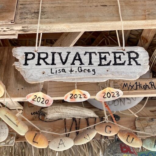
Privateer joins the fleet at the Hog Cay Yacht ClubPrivateer sign with 2023 shellPersephone adds another year
Every February the town, led by Maxine who runs the general store, stages a feast for the cruisers. The money collected from donations and an auction goes to fund the school. Average boat count for February is about 20 boats, but for the parry there were over 40. This year they collected nearly $5K.
The auction
Cruisers donate treasures from the bilge for the auction. Stuff like fishing gear and household appliances are popular and the bidding by the towns folk can get quite animated.
This year’s group photoOn normal evenings the cruisers gather at the hut for happy hour and often some good music.Lisa learns how to weave baskets from locally grown palm fronds
The Hog Cay Yacht Club is a unique stop for any cruiser. In both our visits we met sailors who were closing the circle on their circumnavigations right there at Hog Cay. And they had plenty fellow circumnavigators to trade stories with. Makes for an interesting happy hour.
Conch blowing contestLisa gets ready for Junkanoo
Ragged Island
We visited Duncan Town in 2020 but didn’t make it back there this year.(updated 2023). There are two ways to get to town, a long dingy ride up the trench from the NW, or a long walk up the hill from the anchorage at Southside.
Southside anchorage on Ragged Island
Southside is another anchorage that is popular during a cold front. It is not possible to snuggle up far enough to avoid the swell from the SE through West, but works well for NW through NE and E. Lots of weed with strings of sand for anchoring. We stayed here for a frontal passage in 2020 and needed to deploy our flopper stoppers in order to manage the swell.
Privateer with Flopper Stoppers deployed
(Update 2023)
We made a return trip to Duncan Town this year. It was good to see that they have made some progress with rebuilding from the hurricane five years ago. The solar field is operational and the new school is about to open. A community center and town headquarters building is close to completion. And rumor has it a dinghy dock is in the works.
If you come by dinghy there is a dredged channel from the northwest. All but one of the marker buoys are gone but with good light its easy to find the channel through the flats that leads you to a dredged channel through the mangroves.
Approach to Duncan Town feeder channelThe edges of the channel are easy to see in good light
The dredged channel is mostly >3′ at low but the area in red above, is 2′ or less so watch your prop. The one mark remaining is a small float.
The town is more welcoming than the sign might suggest
We spent about two weeks in the Jumentos and counted ourselves lucky we only had to deal with one mild cold front. On our first cruise down here we saw very few boats but this year there were many. Thirty or forty boats can spread out up and down the chain when the weather is mild, but they all will funnel in to the few protected anchorages when the cold fronts come through. Should you be here for a front, I suggest you find a good spot early in the process.
Fronts aside, a Jumentos cruise provides beautiful scenery, mostly untouched nature and room to stretch out and enjoy the solitude of private anchorages. And you can always find a friendly bunch of experienced fellow cruisers at the Hog Cay Yacht Club, should you look for a little company.


You must be logged in to post a comment.